| Area: William O. Douglas Wilderness | Hike Type: Dog-friendly | Pass: No Pass Req. |
| Distance: 8.2 mi RT | Duration: 4-6 hrs | Difficulty Level: Easy |
| Elevation Start: 3,074 | Elevation End: 5,674 (Junction with American Ridge Trail | Elevation Gain: 2,600 |
| Snow-Free: July – Early-Nov |
There are so many approaches to American Ridge that deciding which one to take can make a hiker crazy.
Fortunately, all of them are scenic so roll the dice and head on out. We opted for the Goat Creek approach which is a shorter approach to American Ridge.
A shorter approach is something to consider now that fall has arrived, days are growing shorter and snow has already fallen at higher elevations. The trailhead is off the Bumping River Road east of Chinook Pass – though the trailhead is not signed it’s not hard to find. It is directly across from the Cougar Flat Campground on the right-hand side of the Bumping River Road (just under 6 miles from SR 410). At the trailhead, you’ll find a kiosk that displays noxious weeds that displace native vegetation if not kept in check and a box with permits to enter the Douglas O. Williams Wilderness (no facility).
The trail starts off level paralleling the highway for about a quarter-mile before it begins a long, steady climb toward American Ridge.
Much of the trail is in the forest but in October the forest was colorful with vanilla leaf turning to gold, mushrooms, and even a stripe of orange witch’s butter along the length of a fallen tree. While the scenery is not dramatic that stretch is pleasant, the air pungent with the faint scent of pine, sap, and mushrooms. We watched a few Douglas squirrels scamper away from us and listened to the steady tap-tap-tap of a hidden woodpecker. We also noted a few hefty specimens of fire-resistant Douglas firs at lower elevations. There were a couple of fallen trees to step over; neither presented a challenge.
As the trail climbs there are occasional glimpses of Little Bald Mountain, Old Scab Mountain and the Goat Rocks. Wear good boots – the trail is sketchy in places where the soil is thin and the grade is steep. Most hikers may prefer trekking poles for this type of terrain where a tumble could result in skinned knees or hands.
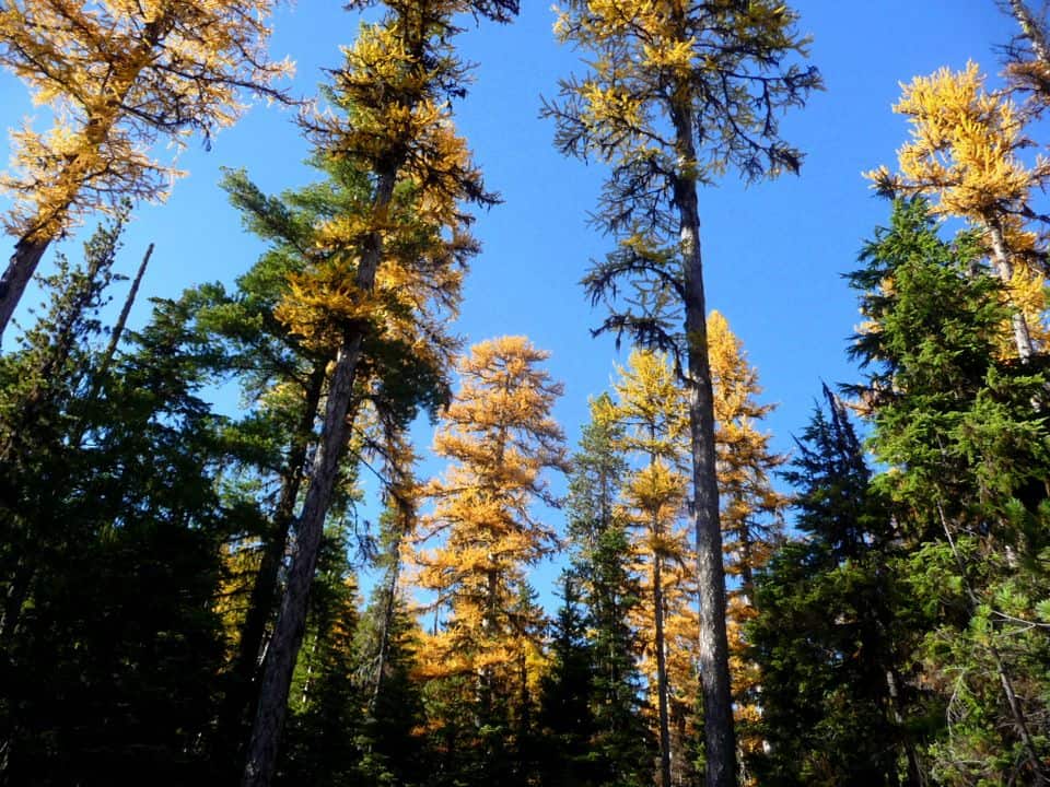
As the trail climbs you’ll pass through a couple of sections where Western Larch is putting on colorful displays of gold and yellow needles.
Western Larch trees are taller than alpine larches such as those found in The Enchantments, Ingalls Lake and near Washington Pass. The brilliance of these Western Larches is more than enough reason to hike this trail; they are resplendent and should stay golden until early November.
Notice how the densely forested foothills glow with the flame of the larches, bright as burning torches. Some the larch trees have lost branches from wind and lay on the trail – here you can see up close how the needles are bundled and formed. You’ll also see that these larches are tall and skinny with much of their foliage near their tips. We are not tree experts but we believe this may because they are competing for light against other evergreens that grow in the region. There are also glimpses of Goat Mountain.
After passing the second Western larch grove the trail re-entered shady pine forest with small patches of the dappled sun at various points along the trail. The climb was steep enough that we never got chilled; it was ideal “hiking weather”. The trail breaks out of the forest shortly below the junction with the American Ridge trail per se. You’ll see a weathered trail sign in the distance. Here the trail is skimpy as it crosses what appeared to be a muddy slope earlier in the year or perhaps an area where the snow melted out later than usual. The tread is indistinct but you’ll have no problem following tread to the junction with the American Ridge Trail. We wanted to go further but it was a long drive back home and we wanted to catch the sunset at Chinook Pass.
We retraced our route and as always were amazed at how much shorter the trail seemed going down compared to how it felt when we were climbing. There are several good reasons to add this to your hiking wish list. In addition to the glory of larch trees in fall this would also make a good spring hike (wildflowers and sun!). Secondly, the solitude is delicious and there are other options open to hikers wishing to extend their hike or backpack (study the map for options). One option is to scramble Goat Peak though we don’t recommend scrambling Goat Peak for hikers without scrambling skills. Study the map for loops and backpacking options.
Getting There
From Chinook Pass continue east on Highway 410 to Forest Service Road No. 1800 (Bumping River Road) and in just under 6 miles find the trailhead on the right with room for about 5 vehicles (it is across from the Cougar Flat Campground). A Northwest Forest Pass is required.
Additional Information: The maps are Green Trails No. 271 (Bumping Lake) and 272 (Old Scab Mountain).
Additional information: Contact Okanogan and Wenatchee National Forest (Naches Ranger District) at 509-653-1400.
Waypoints
| Starting Point: 46.852439998114484,-121.76726902500002 | End Point: 46.852439998114484,-121.76726902500002 |
| Notable Waypoints:
Goat Creek Trailhead (Bumping Lake Road): N 46-55-00 W 121-14-03 (3,086 feet) |
|