| Area: Paradise / Stevens Canyon Rd | Hike Type: Fall Colors | Pass: Natl Park Pass |
| Distance: 1.8 mi RT | Duration: 1-2 hrs | Difficulty Level: Easy |
| Elevation Start: 3,500 | Elevation End: 4,230 | Elevation Gain: 730 |
| Snow-Free: Mid-July – Mid-Oct |
-
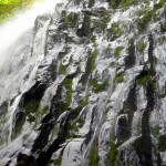
- a view of martha falls

-
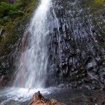
- the waterfall martha falls

-

- seed pod martha falls provides a background

-
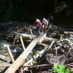
- hikers and wonderland trail bridge near martha falls

The most challenging aspect of getting to this waterfall is finding the trailhead – it took us several tries. This short approach to Martha Falls begins on The Wonderland Trail on the east side (right) of the Stevens Canyon Road (4,150 feet), about a half-mile from “The Bench”, a long switchback between Reflection Lakes and Box Canyon with views of Stevens Canyon (a GPS may come in handy). Trailhead parking is limited – look for a pull-out about a mile from “The Bench” (a long switchback on the Stevens Canyon Road) between Reflection Lakes and Box Canyon.
It’s difficult to spot the trailhead from a moving vehicle if you’ve not been there before; plus the trailhead sign is conspicuous. If you are coming from Reflection Lakes and get to the road-bridge that spans Stevens Creek you’ve gone too far; don’t give up, go back and try again!
Here the Wonderland Trail crosses the Stevens Canyon Road where thru-hikers on The Wonderland Trail can climb to Reflection Lakes, Paradise, and Longmire or descend to Martha Falls and other points of interest.
The trail descends into a quiet, forested valley beginning to show signs of fall. Pock-marked vanilla leaf and ragged trilliums lined the trail; mushrooms poked their dew-slicked faces from trailside foliage and there was that distinct scent of fall in the air that can only be described as “fall”. To me, it always smells a little bit like beets; others describe it as musk or a damp, earthy smell. No matter how this scent affects your olfactory senses it is a pleasant smell despite its not-so-subtle way of reminding hikers that summer has ended.
Soon a prominent yellow sign at a switchback appears, informing hikers the bridge was out, advising hikers to the designated detour. That was easy enough to do; short switchbacks soon led to a partial view of Martha Falls through a curtain of vine maple before the trail drops to the base of the waterfall where a jerry-built bridge crosses Unicorn Creek (Unicorn Creek is the source of Martha Falls). The bridge was not the sturdiest though stream-levels are low enough most hikers won’t find it challenging though the wire that passes as a railing strung between the posts felt a little flimsy.
You don’t need to cross Unicorn Creek to see Martha Falls. You can also pick your way down to the base of the waterfall without crossing the creek; you will probably want to (we did!).
Though stream levels were low the waterfall was still spectacular and when the snow melts next summer we guarantee one heck of a display. From the base of the waterfall, we looked straight up at the mossy cliffs that bracket the waterfall making this an ideal spot for a break on a hot, sunny day – then, the wind-driven mist from the waterfall is guaranteed to cool a hiker’s sweaty brow.
You can also access Martha Falls from the Box Canyon trailhead, (further down the Stevens Canyon Road) – that would be about eight miles round trip. There are also views of the waterfall from other points between Box Canyon and the Stevens Canyon Road along The Wonderland Trail.
We knew we faced elevation gain on the way back to the trailhead so took our time, enjoying views of Mount Rainier and Little Tahoma appearing like a battered galleon in the sky, adrift in a sea of ice.
Getting there: From Longmire drive towards Paradise, turn right onto Stevens Canyon Road, continue past Reflection Lakes to “The Bench” (a long switchback on the road), continue approximately a half mile, walk the road back to the trailhead (no facilities). Chains are required to be carried in all vehicles from November 1 to May 1, an entry fee or appropriate pass is required from the Nisqually and Stevens Canyon entrances into Mount Rainier Park.
Map: Green Trails No. 209S (Mount Rainier Wonderland Trail)
Additional Information: Call Mount Rainier National Park at 1-360-569-2211 to confirm road, trail conditions/closures, fees, rules and regulations and/or check their website: www.nps.gov/mora/
– Karen Sykes
Waypoints
| Starting Point: 46.852439998114484,-121.76726902500002 | End Point: N 46 46′ 03 , W 121 41′ 38 |
| Notable Waypoints:Trailhead: N 46 46′ 12 , W 121 42′ 10 | |