| Area: Paradise |
Hike Type: Family-friendly | Pass: Natl. Park Pass |
| Distance: 1.8mi RT | Duration: 1.5 hrs | Difficulty Level: Moderate |
| Snow-Free: Mid-July –Oct | High Point: 5,940 | Elevation Gain: 550 |
-
- IMG 6965

-
- IMG 6957
-
- IMG 6975

-
- IMG 6976

-
- IMG 6906

-
- IMG 6856

-
- IMG 6867

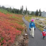
Alta Vista Trail Features: kid-friendly, wildflowers, alpine views, historical, wildlife viewing, autumn colors
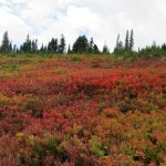
Follow a paved path to a little promontory in Paradise Park for some excellent panoramic viewing. While a tad steep in spots, this trail is ideal for neophyte hikers, visitors to Paradise short on time, and adventurers of all ages and walks of life. You can do this one in running shoes. In summer, Alta Vista bursts with a bounty of colorful wildflower blossoms. In autumn its steep slopes are brushed in deep crimsons and bright oranges. And if this hike’s colorful offerings don’t woo you over—its abundant and whimsical marmots certainly will.
Hit the Alta Vista Trail:
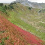
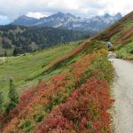
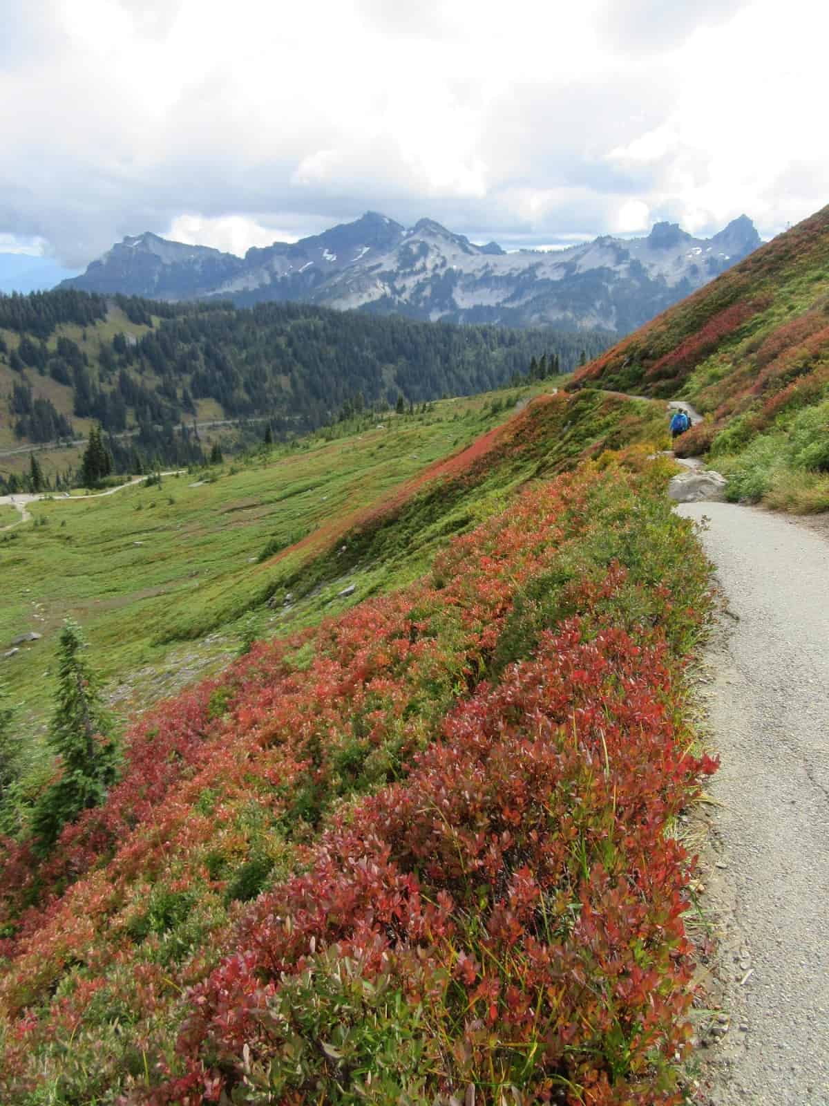
The Alta Vista Trail can be accessed from the main parking lot at Paradise or from the Jackson Visitor Center. The trail can also be reached by taking the Skyline Trail from the visitor center or following the Guide House Trail from the Paradise Inn and Guide House. The trail initially traverses clusters of firs and patches of meadows. In summer, count the blossoms: asters, bistorts, gentians, lupines, paintbrushes, and more. In autumn delight at low bush blueberry bushes carpeting the hillside a fiery red. Vine maples and mountain ashes add touches of yellow and orange to the brilliant reds.
After passing several junctions with interconnecting trails that make lots of loop options, the Alta Vista Trail gets a little steeper. Soon come to a junction that allows for a loop that will lead you up and over the vista—and then beneath it. I prefer to do this loop clockwise for ultimate viewing with Rainier in my face on the way up—and St. Helens, Adams, and the Tatoosh Range delighting me on the way down.
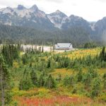
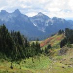
So, head left and make a short and steep grunt to the top of 5,940-foot Alta Vista. The little knob is forested on its western and northern sides and pretty open on its southern and eastern sides. Plop your bum down on a bench, or ease on over to some ledges for head-spinning views. The view south to the Paradise Lodge and Paradise Valley is exceptionally good. Take in too a great view of the jagged Tatoosh Range. Look to the southeast for Rainier’s slightly lower twin, Mount Adams and out to the snowy craggy Goat Rocks. Look to the southwest for a view of Mount St. Helens.
The view directly east is good too offering a different perspective of the Paradise Area. Here look out over the Edith Creek drainage. Locate a stone hut below. It’s part of the intake system for Paradise’s water supply. The area is off limits to hiking, but you can get a good view of it from Alta Vista. Now turn your attention northward to Panorama Point and Mount Rainier. No matter how many times you see the mountain, it always dazzles! And when you are this close to it, feeling its icy breath upon your neck—it’s downright awe-inspiring. Scan all the trails below and notice all of the happy hikers. Paradise is almost always a busy place where hikers young and old, local and from places afar converge to bask in the glory of alpine meadows on Washington’s iconic lofty volcano.
Folks have been coming to this spot since before Mount Rainier was established as a national park in 1899. Just to the west of this spot, James Skinner established a tent camp in 1897. It later was purchased by John Reese of Ashford and became known as Reese’s Camp and the more inspiring Camp of the Clouds. It was a Tacoma-based climber, John B. Hartman who in 1889 bestowed the moniker Alta Vista on this point. The name is Spanish for “high view;” and that it is. Along with Reese’s Camp, these surrounding hills were once marred with developments, roads, and horse paths. A changing attitude in the park over time toward more preservation and less intensive recreational pursuits gradually led to many of these operations being removed. The area continues to recover from the impacts these developments had—and you can do your part by staying on the trails.
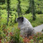
Deer and marmots, however, are free to roam Alta Vista and Paradise Park with impunity. They are almost always out and about and are best observed during the early morning and evening. Marmots are prolific here even burrowing beneath the paved paths. This time of year they are fattening up for the long winter ahead. You’ll have no problem photographing them—helping you fill up your memory card with all of those landscape shots.
To finish the loop, continue walking north and descend to a junction. Then turn right and return to Paradise by traversing steep, open, and bursting with colors meadows beneath Alta Vista. If this hike is too short for you—combine it with a section of the nearby Skyline, Deadhorse Creek, Avalanche lily, or Waterfall trails.
Notes: Dogs-prohibited
Contact: Mount Rainier National Park; https://ww0w.nps.gov/mora/index.htm; (360) 569-2211
Maps: Green Trails Mount Rainier National Park 269S
Trailhead directions: From Elbe, follow SR 706 east (passing through Ashford) for 14 miles to the Nisqually Entrance of Mount Rainier National Park. Then continue east on the park’s Paradise-Longmire Road for 17 miles bearing left onto the Paradise Road. Continue another 2.1 miles to large parking areas and trailhead.
Trailhead facilities: restrooms, visitor center, guest services, ranger station, water.
Waypoints
| Starting Point: N46 47.091 W121 44.482 | |
| Notable Waypoints:
Alta Vista loop junction: N46 47.423 W121 44.141 Alta Vista: N46 47.516 W121 44.188 |
|