| Area: Chinook Pass |
Pass: Northwest Forest Pass | |
| Distance: 8.0 miles, one-way | Duration: | Difficulty Level: Intermediate |
| Elevation Start: | Elevation End: | Elevation Gain: 700 ft |
| Prime Season: Early-April – Early-Nov | ||
-
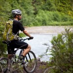
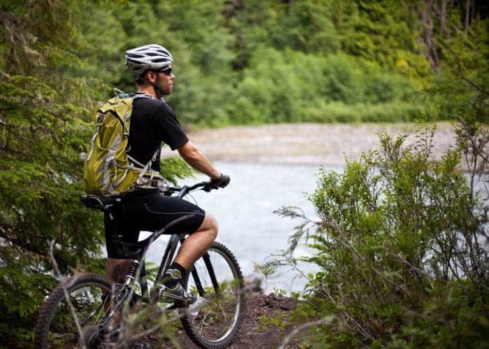
- watching the river
-

- trailhead sign

-

- on the trail2

One of the most popular mountain biking routes in the Mount Rainier region, it’s easy to see why. Skookum Flats is easy to get to, accessible from spring to fall, and provides for a nice technical, albeit not too difficult to ride within a stunning natural setting. And while this trail has had a reputation in the past for its roots and rocks, recent maintenance on it by the Washington Trails Association and the Evergreen Mountain Bike Alliance has smoothed out some of the rough spots.
While the trail is about 8 miles in length, most users opt for a 12.0 mile out and back ride to FR 7160 (which also provides trail access) near the Buck Creek dispersed campground and Ranger Creek Airstrip. The trail continues beyond FR 7160 for another 2 miles or so before ending just shy of the Mount Rainier National Park boundary. Strong and adventurous mountain bikers often combine this trail with the Sun Top Trail and FR 7315 for an epic loop of 22 miles with lots of elevation gain.
The trail takes its name from the Chinook Jargon for strong. And while the paralleling glacier-fed White River is indeed strong, its river banks here aren’t exactly flat. Sure, there are some lush bottomlands along the way, but the trail traverses plenty of small ledges and benches adding a few ups and downs to a generally ascending route.
The entire way travels within eyesight and earshot of the thundering White River. Much of the way to traverses impressive groves of ancient towering conifers. Enjoy cycling along a fern-lined track weaving through colonnades of giant cedars, hemlocks, and Douglas-firs-and beneath a few fallen giants propped high enough to not hinder travel. And there’s a waterfall and some cascading tributaries along the trail as well to heighten the adventure!
From the trailhead immediately enter a dark primeval forest along the glacier-silted river. Prone to jump its banks during winter storms, the White has wreaked some havoc in the past on this trail and its forested surroundings. In springtime expect some wet and muddy spots. The trail does its best to avoid any serious mud holes by utilizing boardwalks and turnpikes.
At about 1.5 miles of fairly level going, you’ll reach the base of Skookum Falls. Here Skookum Creek tumbles from high above, putting on quite a cascading showing during the wetter months. Cross Skookum Creek and continue upriver along the White on rocky at times tread with some minor ups and downs. When the alders lining the river shed their leaves, some good viewing can be had of the rocky Palisades rising high above the river to the east.
Farther along, a few small ledgy areas with some exposure need to be negotiated adding a little challenge to the ride before the trail mellows out to travel along a bench high above the river. When not paying attention to the trail below, be sure to admire the crashing river and the surrounding lofty ancient conifers. At about 5.0 miles the way bends right from where the Buck Creek Trail once diverted left. This route is no longer an option after a flood destroyed the suspension bridge spanning the White River. To now access the Ranger Creek network of trails across SR 410 it is necessary to use the bridge on FR 7160. Continue past the former junction and cross Buck Creek on a solid bridge-then enjoy a fairly easy forested mile to FR 7160. From here either turn around, or continue beyond the road another two miles on a more lightly used track to trails end.
The southernmost section of trail doesn’t see as much maintenance as the northernmost six miles, so expect some brushy areas and perhaps a few downed trees. Also, several side paths diverge along this section to nearby dispersed campsites and may cause some route confusion. If in doubt of the way you can always return on paralleling FR 210 back to FR 7160.
While this trail makes for some nice riding in spring and fall, beware that flooding can occur during those seasons. Note too that elk and bear sightings are not uncommon, so keep an eye out and your camera fairly accessible. In late spring, trilliums, wood violets and other blossoms brighten up the dark forest floor. And note that this trail also sees a fair amount of hiking traffic too.
DIRECTIONS TO TRAILHEAD:
From Enumclaw head east 25.0 miles on SR 410. Just before The Dalles Campground, turn right onto Forest Road 73. Proceed for .4 mile to trailhead located just beyond bridge over White River.
MISC INFORMATION:
• Map: Green Trails Greenwater, WA No. 238;
• Contact: Snoqualmie Ranger District (Enumclaw): Mount Baker-Snoqualmie National Forest; www.fs.fed.us/r6/mbs.
Waypoints
| Starting Point: 47.07798,-121.58564999999999 | |
| Notable Waypoints:
North Trailhead: N 47° 04.678′, W 121° 35.139′ |
|